How to forecast and control soil erosion?
How to deal with underground water pollution effectively?
How to apply water resource to precision agriculture in drought areas?
Dr. Yonggen Zhang from the Institute of Surface-Earth System Science of Tianjin University recently has successfully made the first high-resolution global map of soil hydraulic properties with a physical background”, which is accurate to one kilometer. It is expected to be a revolutionary tool in studying soil hydraulic properties. His paper has already been published in Water Resources Research, an authoritative journal of geoscience.
As the most active sphere of surface-earth system, pedosphere plays a key role in connecting atmosphere, hydrosphere, lithosphere and biosphere as well as ecological system. Therefore, research on soil hydraulic properties is of great importance in farming, agricultural ecosystem, weather forecast, air quality and global climate. For a long time, there were mainly two ways for scientists to get soil hydraulic properties, measurement and prediction. Measuring can only be done by taking samples deep from the earth and sending them to testing institutions, which is very inconvenient for its high cost and length of time. “Predicting” through transform functions is an effective way, only that they are not accurate enough considering that most transform functions are built on empirical formula.
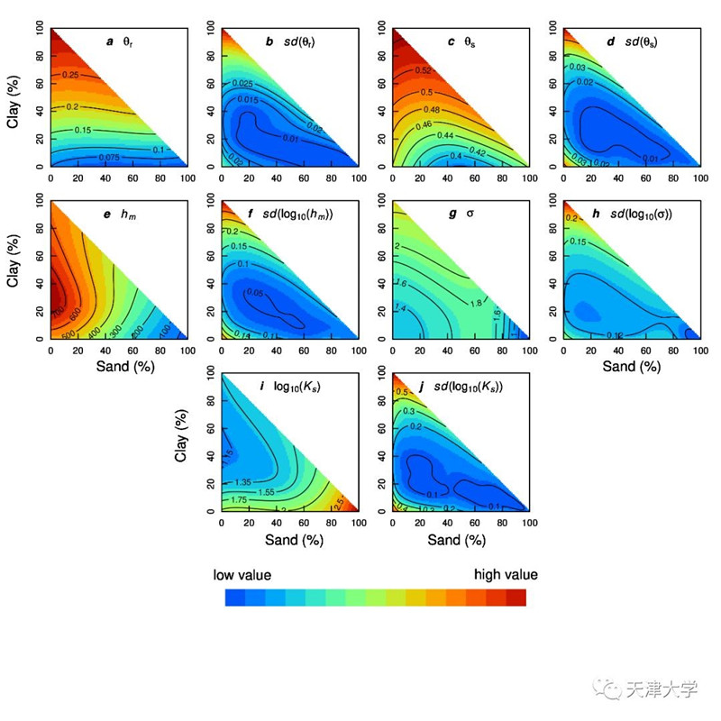
Picture: Distribution and uncertainty of Kosugi hydraulic parameters in soil texture triangle (set volume weight as 1.3g/cm3 and input the percentage of sand, silt and clay into the model).Red means high and blue means low. Letter a, c, e, g, and I represent residual moisture content, saturated moisture content, median pressure head, variance of pressure head, and saturation permeability coefficient respectively. And b, d, f, h, j refer to the variance of corresponding parameters.
By the method of machine learning and random sampling, Dr Zhang built a new soil conversion function model and verified it with nearly 120,000 data extracted from 50,000 soil samples all over the world. As a result, based on Soilgrids, he made the first “super global map” of soil hydraulic parameter with a physical background. With this map, scientists will know the residual water content of the surface soil, saturated water content, the median and variance of pressure head, saturated permeability coefficient, field capacity, wilting point, plant available water and other parameters of any 1 km grid range without going out, which has greatly reduced the cost of soil hydraulic study and controlled pollution .
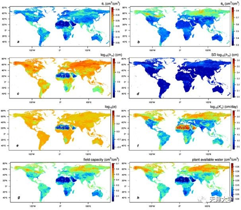
Picture: Global map of (a) residual water content (θr), (b) saturated water content (θs), (c) log10(hm), (d) standard deviation of log10(hm), (e) log10(σ), (f) saturated hydraulic conductivity (log10(Ks)), (g) field capacity (h = 330 cm), and (h) plant available water.
Dr Zhang said, ‘ we will continue to improve the accuracy of the map in hope that our research can help to protect underground water resource, control soil pollution and improve precision agriculture and so on.
address:https://dataverse.harvard.edu/dataset.xhtml?persistentId=doi:10.7910/DVN/UI5LCE
By Wu Chenyu
Editors: Eva Yin & Doris Harrington
