The availability of soil water retention data is essential for quantifying mass and energy exchange processes at the interface between land surface and atmosphere. In large-scale applications, soil water retention characteristics usually are estimated with empirical models that, unfortunately, use non-uniform predictors and were developed on subsets of the global distribution of soils. Their reliability for global estimates is often unknown. Using a global database, Dr. Yonggen Zhang from the School of Earth System Science developed an ensemble of up to thirteen previously published models allowing estimates of soil water retention data under data-poor to data-rich conditions. High-resolution global maps of key points in soil water retention characteristics (and their uncertainties) were produced. These maps suggest that middle and high latitudes in the Northern Hemisphere have larger variability of the estimates. The new model provides more accurate estimates than models currently used in earth system models.
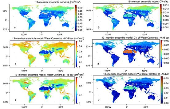
Figure.1 Global maps of mean values and coefficients of variation (CV) of saturated moisture content (a and b), moisture content at -0.33 bar (c and d), and -15 bar (e and f) in 10 km resolution from overall 13-PTF ensemble model for the surface layer. Calculations are based on the surface soil of the OpenLandMap 250 m resolution data but the maps are plotted in the center of the 10 km pixel.
Recently, Dr. Zhang’s work has been published on Geophysical Research Letters. The code and global maps (in GeoTIFF format) of mean values and coefficients of variation of saturated moisture content, field capacity, and permanent wilting point estimated from overall 13-PTF ensemble model can be downloaded from https://doi.org/10.7910/DVN/VPIN2B.
By the School of Earth System Science
Editor: Eva Yin
